070908 #6 Wasatch Front 100M - Out of this World through Heavens and Hells
 A very nice plaque and a belt buckle
- (Wasatch) ... is a study in contrasts: peaks and valleys; trail and scree; heat and cold; wet and dry; summer and winter; day and night; Desolation Lake and Point Supreme; "I can't" and "I will!" Dickens had the Wasatch in mind when he wrote, "It was the best of times; it was the worst of times."
Race: Wasatch Front 100 Mile Endurance Run
Location: Wasatch Mountain Range, from East Mountain Wilderness Park to Wasatch Mountain State Park
Distance: 100 Miles
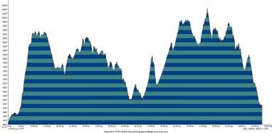
Profile: 16,000m elevation changes over 160K! - 26,882ft gain, 26,131ft loss, highest: 10,450 ft, lowest: 4,880ft, start: 4,880ft, finish: 5,720ft (image/data courtesy of Stan Jensen's run100s.com)
Result: 35hr 50min 56sec, 157/160 overall, 70 drop, Complete Results, Split Result
Photo: 070908 Wasatch Front 100M (264 pictures!!!)
Section Navigator
CHINSCRAPER (Mile 0 - 18.76) Start Line, Francis Peak
BOUNTIFUL PEAK (Mile 18.76 - 23.95) Bountiful "B" (23.95 miles)
SKYLINE (Mile 23.95 - 39.40) Sessions (28.23 miles), Swallow Rocks (34.91), Big Mountain (39.40)
MULES EAR (Mile 39.40 - 53.13) Alexander Springs (47.44 miles), Lambs Canyon (53.13 miles)
BEAR BOTTOM (Mile 53.13 - 61.68) Millcreek(Upper Big Water) (61.68 miles)
DESOLATION (Mile 61.68 - 66.93) Desolation Lake (66.93 miles)
BRIGHTON (Mile 66.93 - 75.61) Scotts Peak (70.79 miles), Brighton Lodge (75.61 miles)
SUPREME (Mile 75.61 - 83.39) Ant Knolls (80.27 miles), Pole Line Pass (83.39 miles)
MILL CANYON PEAK (Mile 83.39 - 93.13) Rock Springs (87.39 miles), Pot Bottom (93.13 miles)
WASATCH MOUNTAIN STATE PARK (Mile 93.13 - 100) The Homestead-FINISH
Wasatch has been a special word with mysteries to me, a non-native English speaker who just started to try some ultra's. Last year, I got to know more about the run when I was tracking the progress of my city heroine Catra Corbett (Dirt Diva) running Wasatch as her weekly 100 milers.
Therefore, as early as a year ago, I have set Wasatch as my target race in 2007. I was simply attracted by its claim "The toughest footrace you'll ever love" I would have run a few 100 milers by then, so Wasatch should be an excellent challenging race for me in 2007. And I guess Wasatch seems far but actually like a neighborhood area among other 100 milers.
I had never had a domestic travel by flight simply to run a race, but I planned to have a few in 2007. When I planned for Wasatch trip, I found that the airfare is pretty cheap and Salt Lake City has wonderful public transit system - RideUTA. These perfectly worked for me to do a thrifty trip - Thrifty Travel Plan for Wasatch Front 100 Miles as a way to save air and money.
Flight to Salt Lake City
I could have caught a bus (#210) to the BART station without driving. The bus stop is about 20 min walk from my home. My wife nicely insists in taking me to the BART station. It is another 20 min ride on BART and there is a convenient AirBART shuttle that takes me to Oakland Airport.
I was at Oakland Airport two weeks ago for Cascade Crest Classic 100M, so I know better where I should do the check in, TSC, and departure gates. I was notified that the flight has about an hour delay. I guess I'll get to Salt Lake City around 1pm. This should be be fine. Even if I am late, there is still checkin after the race meeting. To kill time while waiting for my flight, I only regret to leave a paperback in my luggage, not carried with my backpack.
Old Schooled Running
Well, it's not a ordinary backpack. I am actually in what I will wear during the run except that I am wearing a long pant instead of a short. I always try to save something in addition to air and money. As usual I want to do this trip as a minimalist. I carry even fewer items, so I simply have the FuelBelt backpack with me along with a medium size Napa Valley Marathon duffel bag, in which a sleeping bag and a matte take up most of the space.
From my past 100 miler runs, I figure that I probably only need to change socks during the run. Since I was told that the weather in Wasatch can change at any time, I guess I just carry everything needed all the way. I have done such way without drop bags in Cascade Crest Classic 100M and it worked pretty well. Then why do I need a drop bag this time?
Yes, I'll run without drop bags, plus no crew and pacer. I'll stay with trails, mother Nature, and ultrarunning fellows. I'll live on aid stations. Perhaps that's the old schooled way as it is called. I feel comfortable to stretch the simple way of running to this level.
Get to My Flight
OK, back to the airport. I look around to see if there are any runners like me or anyone that I know of. I was told that there is a small Oakland elite contingent going for Wasatch, including the Tahoe Rim Trail 100M winner Jasper Helenka, the runner-up Mark Giligan, and fast Rob Evan, etc. Later in the race checkin, they tell me they are in the other flight, which is on time.
I pick up the course description and read it a few more time. The profiles still look scary, but I don't know what the course really is like. I guess I just go wherever it wants me to.
Time to board on the plane. As before, I have a window seat, but the passenger next to me is a 400lb guy. He feels sorry by saying the seat is getting smaller nowadays. I am a little squeezed, but have no choice. I can only wish the 2 hour flight to be faster by looking out the window and enjoying the view.
Views over Lake Tahoe, Nevada, and Utah
I expect to see the wonderful view when I am above the Sierra Nevada, in particular Yosemite area. I guess I'll be at 30,000 ft above, I should be able to admire those 14,000er's along I-395. However, the flight actually follows I-80 and flies above the Tahoe Area. It's still exciting to see Lake Tahoe high above. It reminds me of the Tahoe Rim Trail 100M a lot of friends and myself (2nd time) did 7 weeks ago - Spooner Lake, Marlette Lake, Washoe Lake, Tahoe Meadow, Mt. Rose, Carson City, etc. Those nice memories!
 Tahoe Rim Trail 100M Course seen from sky
After that is a huge barren area in Nevada. It looks like desert everywhere. However, I start to see some green hills and then mountains after some time. I have an AAA map at hand to check. There are some National Forests in Nevada and I know Utah is not far.
Near the border in Utah, there is beautiful mountain range. It's so huge that I actually mistaken them as the Wasatch Range.
 Huge mountain range in Utah
Hey the Great Salt Lake is bigger the Lake Tahoe! Nearby there are some salt ponds. They look pretty nice under sunshine.
 Bonneville Sale Flat?
From above, I have a glimpse of the city. It does not look like as crowded as those in Bay Area, but seems to be a pretty comfortable city.
The plane is now lowering. We fly over a piece of marsh wet land near the lake before landing.
Buses to Race Checkin
At the airport, I spend only 15 minutes getting my bag and arriving at the bus top in the parking building. I'm waiting for bus #550 to take me to the downtown. Then bus #220 can take me to the race checkin at Sugar House Park.
The bus waiting time is pretty short - less than 10 minutes. It's enough for me to take a walk around and capture some pictures.
 Me waiting for bus #220
Taking bus #550 is nice for me to take a tour into the crowded area in the city. Along the way, I am completely awed by the Wasatch Range towering and shadowing the city streets. The mountains are pretty huge. I am a little scared at the idea of running there tomorrow.
 Huge Wasatch Mountains shadow the city street
The second bus, #220, is also nice. It gives me a brief grand tour around downtown. It passes University of Utah, which used to host an important events in Winter Olympics in 2002.
After a nice residential area, I arrive at Sugar House Park. A couple of teenagers carrying their skateboards also take off here. There should be a lot of fun facilities in the park for all ages.
The race checkin is right near the pond called Lake Terrace. Far away, I can see a lot of cars parking there. Nearby is a big drop bag area.
 Race checkin area with drop bags
Friends - Hiroki Ishikawa, Oakland Contingent, Hans-Dieter Weisshaar
There are already a lot of people around. I do not see any familiar faces, so I quickly check in, weigh in, and pick up my good bag. As we are close to the 4pm meeting, there are more people. I am happy to see Hiroki Ishikawa (his web site http://www.hirokiishikawa.com/ seems to be stolen right now?), the most famous Japanese Ultrailrunner. He is going to finish Wasatch for the Grand Slam. He said he is a little injured from Leadville 100M last month, but I believe he can get the job done no matter what.
 Me and Hiroki Ishikawa
Mark Gilligan spots me and I have a pleasant chat with the Oakland contingent - Jasper Helenka, Rob Evan, etc. Hope I can memorize more of your names next time. It turns out they were on the other flight and it was on time. I guess I lost a little trust on Delta Airlines. Mark will not run, but crew Jasper. I don't know if I can see him during the run unless he is willing to wait very long time after Jasper leaves at an aid station.
Hans-Dieter Weisshaar is there with his wife Susan. They hug me right away. I met Hans two weeks ago in Cascade Crest Classic 100M for the first time. I am proud to know this Ultra legend, who owns the number of finished 100 milers - over 100 and counting!
Friends - Dean Alan Dyatt, Kelly Ridgeway, Andy Kumeda, Janice O'Grady
Dean Alan Dyatt calls my name during the race meeting. We don't know each other, but he probably recognizes me by my ever-present Ohlone Wilderness 50K T-shirt, which appears in all my race photos. He likes my ultrarunning pictures. We actually run with each other in the beginning during the run and finish it within 10 minutes!
I also meet Kelly Ridgeway (Running Free), who I had fun time chatting with in Miwok 100K. We wish good luck to each other. Andy Kumeda is there too. He is from Southern California. We first met at Western States 100M during my safety patrol. He has run a lot of races and I hope to see him in the run. Janice O'Grady calls my name. She and Tom O'Connell were Quicksilver 50K/50M for years and retired this year. We exchanged a few emails about this run. We wish good luck for next day.
Friends - Jamshid Khajavi, Randall Gillete, Charlie Crissman
Jamshid Khajavi, with several slam's in bag, runs for the Grand Slam. I have heard about him long ago (another ultra celebrity). I first met him at the start of the climb to Robinson Flat in Western States 100M. He comes with his pacer Randall Gillette.
They are nice and happy to give me a ride to the race start at East Mountain Wilderness Park on their way to the hotel in Ogden. I very appreciate this help; otherwise I have to walk with my luggage for 7 miles and that should affect a lot for the race next day.
Along with us is Charlie Crissman, the Cascade Crest Classic 100M RD. Charlie ran Wasatch a few years ago. He would like to run a fast time tomorrow. We have a nice dinner at an Italian restaurant near Charlie's hotel in the downtown and talk about everything about running near the Seattle area.
The Wild Night
After a little route finding on I-89, we finally get to the race start East Mountain Wilderness Park. On our way, Jamshid and Randall also plan the logistics how they get here tomorrow morning. The park is a little primitive with only a small dirt parking lot. I estimate 20 cars will be very crowded over there. There is no drinking water as I expected, so Jamshid kindly gives me a 20oz bottle of water for the night.
I like to stay at soft dirt ground, but I have difficulty to find a spot. It's either full of horse dumping everywhere or not safe from being run over by a car. I have to look for spots outside of the parking lot. I want to save my legs in any walking activity, but I'm lucky to find a spot near the gate along the road. That should be safe for the night as long as the barbed wired gate does not fall on my head.
 That's all for the night
Not many people and cars are around. It's quite peaceful. I enjoy the feeling of lonely moment. It gets darker, but still warm even at 5,000ft here, according to Jamshid's altimeter. The gown sleeping bag turns out to be a little warm. I would like to take it away. However, surprisingly, I am bothered by the mosquitoes. They are hovering around my face, the only exposed body part. I have to wave them away once in a while when I feel like getting mosquito bites.
Luckily, the temperature keeps going down. As it gets cooler, the mosquitoes gradually leave me alone. It's totally dark except the city lights a miles away. There are getting more stars in the sky, but I only want to get enough sleep. I guess I can enjoy the starry sky tomorrow night in the run.
As I get used to the darkness, a few cars pass by and bother me with strong headlights. There are even two times that patrol cars stop, wake me up, and nicely check me. The policeman are aware of the run, so they wish me good luck. However, I am waken up about every 20 minutes like these.
Busiest and Shortest One Hour
When I feel like being into the sleep, my alarm goes off. It's 4am and runners are coming here for the start. I have to get up. This reminds me of the Burning River 100M that I did 5 weeks ago. I did not have enough sleep as well and felt sleepy during the run. I'm going to take this and hopefully I can get it through.
The one hour before the 5am race start is the shortest I've ever had. I quickly go to a port a john, but no good. I go back to my sleeping site and wrap up all my stuff in dark. I need to be careful to have things in my run and not miss any items. I spend some time to get my sleeping bag and matte into the bag. I also grab a few bottles of water and pour it into the water bladder. It's not all easy to do all these in dark. When the race starts, I just finish packing the luggage. I hand it to a volunteer so that it can be shipped to the finish area. When I start to run, it's been past one minute. This is fine because there are over two hundred runners waiting to be squeezed into the single track right at the start.
Back to Section Navigator
Chinscraper Section : 18.76 miles (0-18.76), 5hr 2min 35sec/5hr 2min 35sec (normally 3.5 - 6 hr)

Start => Grobben's Corner : 14 miles (0-14), 4 hr 12min 29sec /4 hr 12min 29sec
Nice Rolling Hill Start
The trail begins with a single track. Unlike Miwok 100K, which also has a single track in the beginning, it dose not have a 200 yard sand beach to spread out the runners. All of us have to settle to walk. This is fine since there are 100 miles to go.
I quickly catch a few friends. Hans-Dieter Weisshaar from German has run over 100 100 milers at 67 year young. I met him at Cascade Crest Classic 100M and was impressed with him achievement and performance (He beat me at the downhill to the finish).
I am surprised that he uses trekking poles in the run. The discussions on Ultrarunning List, Karl Meltzer WasatchSpeedGoat, Scott Jurek Blog about them being used in UTMB are still fresh. I did not notice this usage is ever mentioned in Wasatch Front 100M. But since this run is so technical, using trekking poles should be appropriate as in UTMB. Later I found a few other runners using them as well.
 Hans starts in dark with trekking poles like some other runners.
I also catch Janice O'Grady, the former many year RD for Quicksilver 50K/50M. She retired this year and moved to Colorado. After she living there a few months at high altitude, I guess she will have no problem with the altitude in Wasatch.
It's all pitch dark but there are not many stars in the sky. Instead, I enjoyed the starry light from the runners and some city lights around me. Looking at the runners at the corner quarter mile behind, I suddenly have a very bad ankle twist. It is the worst in the year and happens at virtually flat trail at mile one. I almost scream out and become very nervous about how I can continue for the following tough 99 miles day and night. I have to stop and walk. Janice kindly asks me about it, but I can only say I'm fine. I walk at the side of the trail and a couple of runners pass me, including Hans-Dieter Weisshaar.
I walk a few minutes and feel better. I am motivated by how I finished Miwok 100K this year with the similar situation. I had several ankle twists in the beginning and thought about quitting the run. I continued and finished it in the end. I am simply wishing that I have the same luck this time since this is my target race this year and I have gone a long way here in the trip.
I started to run more and catch Janice after a while. Perhaps I'm still in awe of the run and my ankle issue, we don't have much talk. We carefully pass a few water crossing. It's all flat, or slow rolling hills, and runnable until we get to a small parking lot, where there are a few volunteers collecting the empty water bottles that we carried from the race start. I would like to collect the spring water later, so I just keep my own one because it is not easy to fill the water bladder from the spring.
There we turn right and start the monster - 5000 ft climb in 5 miles! We'll get to Chinscraper, a word I have no idea about.
Chinscraper Climb
I have prepared for the steep climb mentally, so I start to walk. I know the altitude is there waiting for me as I go higher. I start to drink more. It is now single track. I have to follow a slow string of runners ahead of me. I can pass them, but I would rather stay at comfortable level to please the altitude beast.
 Dean Alan Dyatt (without shirt) and a string of runners
Dean Alan Dyatt is right in front of me. He just caught me at the race briefing yesterday and told me he likes my ultrarunning photos. I find I have to keep a safe distance from behind so as not to be hit by his trekking poles. I was surprised that he wears no shirt, while I feel cold in my Ohlone Wilderness 50K T-shirt.
Talking about T-shirt, I spot a cool one as we go higher. The trails becomes steep and rocky. A runner behind wears a UTMB shirt! He just finished the prestigious race two weeks ago! He comes to run Wasatch. I guess this will give a good comparison about these two runs since they have very similar amount of climb and distance.

The city is still in the wake at about 6-ish, but the view below becomes awesome. I guess I am at over 3,000 ft above. Hey! it's now 8,000ft. No wonder I start to feel dizzy. Within short time, I have some light chest pain. I think it's time for me to stop to take more breath. Yes, it's time to take more picture!
 Me and Michael Perkins
After some breaks and distractions from the views, I feel better and start to move faster. The trail is simply straight up as the only way to accumulate 5,000ft within the short 5 miles. Later I think this is a taste (or test) for the remaining Wasatch type climbs - straight up and down - no compromise.
 Straight up climb with awesome city view behind
Someone points me a rock far away at a mountain top is where we'll go to. I guess it's the Chinscraper. I feel nervous about how we can ever get there. It seems that we have got to a flat area. I's pretty high and about 9,000 ft. We then crest a meadow and enter a small woods. We exit the woods within a minute. What stands in front us is the huge rocky monster - Chinscraper!
Brandon Sybrowsky flies by with his fashion sporty beard. His brother Travis comes immediately behind. I can not believe any one can run that fast at such a steep section. But they are several years Wasatch veterans - Brandon 15 times finishes, along with many respected winnings in other great ultrarunning, and Travis 6 finishes (from my fainting memory)!
All of us are now running at the narrow single track around the cliff to get to the last pitch to the summit. I can hear a few screaming from the top, but dare not to check closely. I guess they are from those runners finally get to the top. It's a temporary relief from the grueling climb. I need to be very careful about the footing. Sometime it becomes very rocky full with football size loose rocks. Sometimes a fall means 10 feet straight slide down from the side.
 Approaching the final pitch
We get to the final pitch at right hand side. We turn right and start our class III rock scrambling. It is extremely steep and rocky all the way to the cliff - much worse than Encarpment or Cougar Rock in Western States 100M, or Goat Rock in Cascade Crest Classic 100M that I have ever experienced. I feel fortunate that I use a backpack instead of handheld water bottles. I am able to apply my hands to position myself and pull myself up.
 The final pitch - class-III rock scrambling
Wow! What a great view at Chinscraper!. It is 9,300 ft, about 5,000 ft above the city right below our feet. I must scream as well - for the accomplishment or the relief, although I'm not sure. I guess the scream I heard earlier must be mixed with awe, joy, and relief. The reward is truly out of this world!
 The Chinscraper!
The way to spring water
I'll be wrong if I think the trail becomes easier after getting to the top at Chinscraper. But only for a while. Still full with the excitement from Chinscraper summit, I happily run on the nice rolling hill along the mountain.
My water bottle is now empty. I do have 60 oz water in my water bladder, but would like to portion it for this long and unknown 18 mile section. I have drunk from my water bladder for a while. It's salty with some secrete ingredients. I need to get to the spring for more plain water.
Cool Springs at mile 8.93 is ahead, but no one stop for it. The water is also slow, so I better skip it as well. By passing the spring, I'm pleased to know I have run 9 miles - half of the section. The next spring should be not be far - 1.5 mile to go.
I run fast and it seems that the suffering from the altitude was a super fast altitude acclimatization. I am able to fly by any technical sections with all my might without feeling out of breath.
It seems that I am running back and forth with Bonie Jo Shupe. We finally get to the Landis springs at mile 10.58. We and a few others stop for the water. The water is strong and it takes only 5 second to fill up my 20 oz bottle.
Wow! the water looks so clear and the taste is also great. I guess I can sell it on the market!
 Landis Springs at mile 10.58
The nice section is soon gone after we fetch the spring water. About a quarter mile away, we turn left and start to do one straight up climb along the ridge. It's steep and long. A long downhill comes after it, but at the end of the it immediately comes another long and steep climb on the ridge

More climbs after Chinscraper
A few men come down from the top with guns. I chat with them whether they did some hunting during my sleep hour last night when I heard some gun shots from mountains above.

Need to pass two big mountains
Once we finish these two climbs, the course becomes wider. It looks like a fire road. It's pretty flat and I feel like running in the sky with the city view 5,000 ft right below.
Grobben's Corner : mile 14, 27.68 sec/4 hr 12min 57sec
The footing is very nice and we soon get to the Grobben's Corner, where the RD John Grobben drives and has a trunk of water. My bottle is filled. I'm happy to know I have run 14 miles and the first official aid station at Francis Peak is only 4 miles away. However, it's been 4 hours. I am a little disappointed that I have run my slowest half marathon! But I don't mind since I have another 86 miles to go.
 Grobben's Corner with plain water at mile 14
Grobben's Corner => Francis Peak : 5 miles (14 - 18.76), 49 min 38sec /5hr 2min 35sec
Not far away, I spot a huge white ball at the top. This is actually I saw yesterday on my way to the race start. It was so high and far away, but now it is just in front of us. I was amazed how far and high I have run. This is only 15 miles into the 100 miler!
 Run toward the sky
As we are so close to the mountain top, we are running across the sky. The surrounding is pretty barren. It makes me feel like being in another world - also away from the civilization, which is far below. This is such a great feeling that this four miles to the aid station seems to pass by so fast.
Back to Section Navigator
Bountiful Peak Section : 5.19 miles (18.76 - 23.95), 1hr 32min 43sec (normally 1-2 hr)

Francis Peak : mile 18.76, 6min 30sec/5hr 9min 5sec
 Francis Peak Aid Station at mile 18
A volunteer is taping the video on me. I turn around and around saying that I'm running without drop bags. These are all I have. Well there are 82 miles ahead, day and night, with all kinds of extreme conditions. I better keep my finger crossed and wish me good luck. I have my water bladder filled. I eat enough and go.
Francis Peak => Bountiful Peak : 5.17 miles (18.76 - 23.95), 1hr 26min 13sec/6hr 35min 19sec
Even with the downhill prior to the aid station, I guess we are still at top of the mountain range, so we are treated a nice section of flat dirt road.
 Flat dirt road leaving the Francis Peak aid station
Apparently, this is a multi-use trail. There is an ATV. A runner stop to chat with them. Half mile away, there are even motorcycles! First time I run with them on trails. Gun shots, Hunters, ATV, and now motorcycles - Interesting!
 Run with motocross
The trail stays with the same width, but becomes rolling hill and not in good shape. There are loose rocks along the trail, which is now Utah specific red.
 Red rocky road
The trail becomes a single track. I can not see the profile ahead, but can only follow the rollings. There are overgrown bushes and a few easy water crossings. At the end, the water crossing means the finish of a downhill and the start of a climb. It seems that we are entering a trail without much maintenance. There are fallen logs across the trails. This is fine to me now since I just came back from the infamous "Trail from the Hell" in Cascade Crest Classic 100M two weeks ago.
 Not much maintained trail
The trail is actually slowly up. After a few small water crossing (Not really because some are just muddy), the real climb is there. It is as steep as in the Chinscraper climb - something like 1,000ft per mile. I feel fine and stay patient because I know this will not be long. The Bountiful Peak aid station is finally in sight.
 At the top of the hill is Bountiful Peak aid station
Back to Section Navigator
Skyline Section : 15.45 miles (23.95 - 39.40), 4hr 38min 8sec (normally 3.5-6.5 hr)
 Profile (Description)
 Bountiful Peak aid station
Although my pace is slow, it's great to get to this aid station at mile 23.95 - almost a quarter of the run! The aid station is set up at the ridge. I think we are starting running at the mountain ridge.
Bountiful Peak => Session Mountain : 4.28 miles (23.95 - 28.23), 59min 2sec/7hr 37min 4sec
The trail is wide and not very hilly, but has rocks everywhere. After a while, I somehow hear a few screaming far away. Sounds like asking for help. I'm not surprised giving this very tough course. I can not move any faster, but only hope to get there soon to see if I can help a little.
As I get closer, it turns out to be several mountain goats "chatting" in the woods near the trail. I saw deer before, but never goats. This is the first time I spot goats in the run. I guess this is possible in Rocky Mountain Area and why the Wasatch legend Karl Metlzer has his blog named as WasatchSpeedGoat.
 Sheep or Goats chatting in the woods
There some uphill but not steep. It's pretty runnable. The view is wide open at 8,500 ft high here. I can see a couple of runners nearby. I caught up Rick Gates. Without knowing who he is, I asked him about his experience of the course. I am totally stunned when he tells me he has finished Wasatch 23 times and is the record holder. How can he have run this tough course so many times and still enjoy? See how he is smiling! I think it's the history, the challenge, and the beauty that attract people to keep coming back! I guess I will as well. I can not believe my eyes that I am running and talking with the Wasatch legend here.
 Rick Gates smiling, with the record of finishing Wasatch 25 times
Not sure if I'm not smart enough. I pass Rick when my legs are OK. Am I too fast now?
From behind, I catch Marcie Nielson and have a chat. She wears a T-shirt about Grand Slam 2006. Pretty neat. Guess some day I'll have one such T-shirt.
Session Mountain : mile 28.23, 2min 16sec/7hr 39min 21sec
 Session Mountain aid station
Session Mountain => Swallow Rock : 6.68 miles (28.23 - 34.91), 2hr 4min 39sec/9hr 44min 1sec
We begin with a short downhill and enter a woods. This is first time to have rooted trail in the run. The trail becomes steep and switch back. Everyone slows down to walk and we somehow stay close together till the top. All of us feel awed about the mountain view.
It's afternoon and I start to feel the welcome sunshine. However, it's comfortable warmth at over 8,000ft in elevation. As we climb higher, we leave the tree line and run at the mountain ridge. The view is wide open and we can see vast mountain range far away. It seems that I can find out where I have run earlier and I am amazed how far it is right now. But it's only 1/3 of the 100 miles!
 Winding through a vast mountain ridge
We simply follow the mountain ridge and wind around them. The trail becomes single track and more technical with loose rocks. I think it's because we are going to the next aid station called "swallow rocks".
Since we can see very far at the ridge, I try to locate the aid station. This is a long and difficult section. After an hour or more, I finally can spot an artifact far away and trail to get there. I guess it's the aid station and I get a little excited to keep moving. It's pretty far, about 1 mile in straight line distance, so I need to have another 2 mile worth of trail to get there. At least, I have a goal (and hope) in sight.
Swallow Rock : mile 34.91, 6min 47sec / 9hr 50min 48sec
 Swallow Rock aid station
I finally arrive at the aid station. It seems to sit at the top of a cliff. A medium size tent is full of runners and volunteers. I eat and drink a lot. I say hello to Brandon Sybrowsky and his brother Travis. They have stayed there for a while. I'll leave right away, but expect them to catch me soon.
Swallow Rock => Big Mountain : 4.49miles (34.91 - 39.40), 1hr 23min 3sec / 11hr 13min 51sec
Since the aid station is right at top of the ridge, the following trail basically stays on the ridge. We completely run along the mountain profile. The view is again simply magnificent.
 Awesome ridge running after the aid station
Like the previous few miles, the trail is still pretty rocky. It's becomes very tough on some steep downhill part.
Amazingly, there are a lot of various terrains along this 4.5 mile section. One time, I enter a woods area. Mike Price nicely take a picture of me.
 Me in a woods (Thanks Mike Price)
Without wonder, The brothers Sybrowsky catch me again. We actually catch each other all the way from the begininng till near the finish. Not at all that I am fast but because they want to run slowly and enjoy the run after so many years of speeding and racing! And I am fortunate to have such a rare chance to run with such elite ultrarunners.
 Team Sybrowsky enjoying the run
After an hour, there is a long steep downhill full of loose rocks. It is so steep that walking is not possible and running is dangerous. I slip and twist my ankle twice. It's so painful that I have to stop and sit down to tender my ankle. It's not easy to sit down as well because I am right at the narrow steep downhill. I have to keep moving in a cripple way after sitting on the trail for 10 seconds.
I believe I feel better after a few minutes. I don't remember the details, but I did get encouraged with the road, parking lots, and the aid station in sight, just a few hundred feet right below.
 Pirates waiting for us at Big Mountain aid station
Within a minute, I'm glad to see the welcome signs toward the aid station.
Back to Section Navigator
Mules Ear Section : 13.73 miles (39.40-53.13), 5hr 20min 1sec (normally 3-5 hr)

Big Mountain : mile 39.40, 2min 20sec / 11hr 16min 11sec
Crossing a road, I get to this major aid station. It feels like the Highway 49 aid station in Western States 100M. I am very excited to see a lot of people there. I seem to forget the falls and pain that happened not long ago.
 Big Mountain aid station
I quickly weigh in, grab some food, and have my water bladder filled. A volunteer is assigned to me when I mention that I don't have crew. I plan to clean my shoes and feet, and then change my socks. I need help to have wet and dry tissues, and Vaseline ready. My feet are pretty damage after this 40 mile of tough running.
A lady calls me from behind while I sit in a chair. She is Susan, Hans-Dieter Weisshaar wife. I met Hans at Cascade Crest Classic 100M for the last 15 miles and he beat me at the finish by a few minutes.
At the age of 67, he already finished over 100 100 milers - a world record! I remember passing him very early today, but he'll catch up when I get exhausted very soon. I tell her that Hans must be a few minutes behind me.
 Susan helping Hans
As I stand up to check the food table, Hans comes in. Susan takes care of him. Before I am ready to leave, he has already left and stays a few feet ahead of me. Even with the help of his wife, I am still amazed such short time he spent at the aid station.
Big Mountain => Alexandra Spring : 8.04miles (39.40 - 47.44), 2hr 38min 53sec / 13hr 55min 5sec
Leaving the aid station, We start with a steep climb for 500ft elevation change to the mountain ridge at 8,000ft. Hans is only a few feet ahead of me with his efficient way to overcome the climb like I learned from him in Cascade Crest Classic 100M.
Phil Rosenstein and his pacer pass us after a few minutes. I met Phil right Highway 49 aid station in the Western States 100M this year. He is from Wisconsin and likes to race all over the country. Now he is doing both Grand Slam and The Last Great Race this year.
 Marcie Nielson and her pacer ready to pass me
I somehow start to feel tired and many runners pass me. Marcie Nielson and her pacer pass me, too. At the end, it is only a guy ahead of me. He looks also the same tired or worse than me so I can catch him. I guess we are stricken by both altitude and climb. We run together and chat a bit. He actually has kids learning Chinese. His family will wait for him at Lamb Canyon. Perhaps I can talk with his son in Chinese later. It turns out I never see them until at the finish area.
We finally get to the top of the climb. While we enjoy the view for seconds, a group of runners come up as well, including the Brothers Sybrowsky and Allan Holtz. I invite everyone for a group picture.
.JPG) A group picture after a tough climb
A group picture after a tough climbI want to hold back a little, so I let everyone go ahead. It's rolling but at high mountain ridge. The view is amazing that I can see the entire mountain range.
I start to feel the close to the end of the day. The sun is lower and has all its lights shining on a pretty lake.
 Dell Lake under the afternoon sunshine
It's mostly downhill with only a few short uphill in between. They are steep and rocky. The trail is completely exposed. It's not warm but starts to become chilly as the wind blows strong everywhere. We'll go down another 2,000ft to the aid station called Alexendra Spring.
Alexandra Spring : mile 47.44, 12min 6sec / 14hr 7min 5sec
 Alexandra Spring aid station
The aid station just sits within the golden grass field at the end of the downhill ridge. There is a volunteer without shirt and have all Indian paint on his upper body. It's entertaining. Thanks!
 A volunteer from Indian Tribe?
It's windy and becomes a little chilly. I figure that I'll start nightly running very soon. I decide to add a long sleeve for the next section, which I think I'll enter the night. I also check my flashlight, but don't know that it becomes low batter later when I start to use it. Eating, drinking, and chatting with other runners soon ease my concern and motivate me a lot.
 Me in long sleeve preparing for night running
Alexandra Spring => Lamb Canyon : 5.69miles (47.44 - 53.13), 1hr 50min 59sec / 15hr 58min 10sec
The Sun is going down. The sunshine dies the entire field into a splendid golden area. The trail from the aid station goes straight all the way to the end. The hill is slowly rolling. Having a long sleeve, I feel safe to this exposed and windy part. A little civilization appears as a paved road along the trail but stays about 200 yards away at the right hand side.
I thought I am alone as I find no one ahead or behind me. After 10 minutes or so, Bonie Jo Shupe and her pacer (Eric) pass me. Bonie was pretty strong in the beginning when both of us passed each other after Chinscraper section. I don't know how she slowed down afterwards. However, she looks great and I'm glad that she picks up her pace right now. I guess pacer helps!
I patiently run on this straight line trail that looks like forever. I pass a runner and his female pacer. He looks miserable and walk slowly. I encourage him to take it easy and will recover later. After five minutes or so, they catch me and all of us show smiles about how he recovers so soon. We run faster and I point out a left turn into a bushy trail so that we nearly miss this turn. I let them go ahead. It's immediately a steep climb and we are winding through thick bushes.
 Sun setting down with straight trail with no end in sight
It's darker now and its time to use my flashlight. Just like my light is not bright enough due to low battery, I start to feel tired after the whole day covering such a tough course. As I sense the lights from runners behind, more and more pass me and it seems to lower my morale a bit. I struggle and move slowly. Perhaps I walk more often.
After a while, it seems that everyone has passed me. I feel like running alone in dark with my dimming light. The trail keeps going down. I can see some grand scale of civilization down below - a highway! The aid station must be there. With lights here and there down below, it's still hard to tell where the aid station is.
The trail switchback down. I finally enter a thick tree area that the sky is almost fully covered. At one place, my weak flashlight indicates that there is a water ahead. However, the light is so weak that I have hard time to find a way to pass it without wetting my shoes. The shoes are GoreTex, but I don't want to test them right now when my condition is not good.
After a while, I feel that I probably get to the ground level. A light from behind tells me that another runner speeds up and get ready to pass me. After I let him pass, I hear a pretty strong water flowing. It sounds like a small river ahead. I pray and hope it not a deep water crossing. I start to go steep down to the river. Hey! there is a bridge.
Crossing the bridge and climb up a levee for 20 yards, I complete half of the distance and arrive at the Lamb Canyon aid station.
Back to Section Navigator
Bear Bottom Section : 8.53 miles (53.13-61.68), 3hr 47min 31sec (normally 2.2-3.5 hr)

Lamb Canyon : mile 53.13, 38min 2sec / 16hr 36min 12sec
The aid station is like a night party with lights everywhere. And there are lots people, at least 200. Although I was very tired earlier, I feel pretty excited now. I sit down and regroup myself. I decide to put my camera into a bag. I sense that I probably won't have a good night pictures and need to fight for the nightly running coming ahead.
I follow the smell and walk to the grill stand. While I am waiting for my order of a hot sandwich, a volunteer tells me that it will be very windy ahead.
Lamb Canyon => Upper Big Water : 8.55miles (53.13 - 61.68), 2hr 59min 5sec / 19hr 35min 17sec
Leaving the aid station, I'll cross the highway 89 from under. The check out area is over a hundred yards away from the checkin. I started to feel a strong windy coming toward me through the tunnel under the highway.
After check out, we are running at a single lane wide paved road along a river. I can hear loud water flowing. Actually, the road seems to set up at the top of the river because there is water flowing at both sides. Left side is like a river, while the right side like a creek.
This is Lamb Canyon, so it's very windy when all the wind blows through this narrow area. And it's cold. I catch up a guy staying low, wearing an extra jacket. It's all uphill from 6,000ft at the aid station. There is over 2,000 ft climb coming right now.
I have only one clothes left - the thin AR50 jacket. I planned to wear it later when I get to the top and the ridge. I figure it will be more frigid there. However, the chilly wind has changed my mind. I'm not sure if I can keep moving without more clothes right now. I think I will definitely start shivering very soon. I better to wear my last clothes now at the nice paved road. When I enter the woods, it will be more difficult to do so at the single track steep hill.
I find a rock at the road side. I sit down to fetch the jacket, better hat, and gloves. I have to do all these very carefully because I might drop the small handheld flashlight to the creek. Within a few minutes, some runners pass me. I now feel a little better with all my clothes on.
After a mile or more on the paved road, we make a right turn down from the road. There is a small bridge to cross the creek. There is a group of runners resting or preparing at the entrance.
Across the bridge begins a narrow steep uphill single track in the woods. After a while, the switchback is over. The trail becomes a straight up. There is water flowing at the left side and the trail follows it for long way. I guess it's the creek I crossed earlier.
The trail is steep, so I guess I'm getting higher and higher above the creek. However, the loud water flowing still echoes through the entire woods. I'm now alone without anyone around. There is even no light I can see through the woods from any runners. I guess I have gained over 1,000 ft since the aid station. It should be at 7,500 ft.
The altitude has come to me again! I feel exhausted and want to stop and rest. The trail is so narrow and tricky that there is no place to sit down at the trail or at the side. At last, I stop and stand with my eyes closed. I have to open my eyes after a few seconds for the fear of falling asleep and falling down at the trail or sliding down to the side.
It's still windy even in the woods. It's getting cold. I better keep moving. Looking far above, I try to find out the top that I'll get to. I can see the sky, but the top of the mountain seems very high and unreachable. The woods just extends forever into far distance.
Don't know how much time has passed. I finally get to the top at 8,100 ft. This is the worst suffering since the run started. Shall I say it's a Hell? At the top, I seem to be able to see city lights far away down below. There are two female runners there. I'm not sure if I catch up them or vice versa.
The trail immediately drop down on a steep single track. They fly down with me following behind. I feel better now perhaps because I don't need to work that hard as earlier on the climb. The altitude does nothing to me.
After about 1.5 miles downhill, the course continue on a single lane paved road. I guess I have climbed out of Lamb Canyon down to the other side. There are cars around with strong car lights. I have to use my flashlight to show my presence. These are the crew cars from or to the aid station ahead.
We'll stay on the paved road for over 3 miles. There are runners ahead and behind me. We try to run a bit on such a nice surface, but the paved road is mostly steep. We soon give up and walk more.
I think my mental is low so that I have been scared a few times by the strong lights from behind. I mistaken them as the car light coming and have to look over my shoulder.
Walking three miles with exhausted body makes it feel like forever. I wonder why this is so long. Will we keep going on to make up the elevation drop we had on the previous downhill? I am concerned with such an idea, but the only thing I can do is keep moving.
Every time I see some lights ahead, I am hoping it's the aid station, but it turns out to be a car coming down. With several frustration like this and not knowing how much time has passed on the paved road, I spot a parking lot ahead without mistake and the aid station is just a hundred yards after that.
Back to Section Navigator
Desolation Section : 5.25 miles (61.68-66.93), 3hr 3min 46sec (normally 1.2-2.5 hr)

Upper Big Water : mile 61.68, 28min 26sec / 20hr 3min 43sec
This aid station is called Upper Big Water since we climb up to 7,700 ft along with another creek at the right side to get there. It's also called Millcreek. I guess it's the name of the creek.
It's another nightly party here. There is so much light in such a dark area. A big tent is set up for cooking hot food. There are many runners around, resting for the coming challenges.
I ask around what the condition will be like ahead. I already feel cold with all my clothes on. My answer is it'll be colder and windier ahead because we'll keep going higher to 9,300 ft at the next aid station - Desolation.
I have to say I'm in very bad condition. I have the idea of quitting, but still think if I can move a little farther and have the quitting at the next aid station. What if it rains or snows, can I survive it and make it to the aid station? This is my long waiting run this year. This is my target race. Shall I give up or give in now? I have the doubts. Say I can move harder to generate heat when the weather becomes worse.
With the allure or fear of the name Desolation, I go ahead.
Upper Big Water => Desolation : 5.25miles (61.68 - 66.93), 2hr 52min 38sec / 22hr 56min 21sec
The trail enters the woods with everywhere so steep. Oh my god! It seems to be the same thing as the previous Hell. The trail goes straight up and steep. There is no evidence where the climb will end. The top of the mountain is not seen at any direction. Looking ahead is only tall trees lining up higher and higher.
But at higher elevation, I feel worse now. I'm moving towards 9,000ft. On the other hand, I feel numb at my body and mind. I am extremely exhausted. I have no control over my body and am doing sleep walk. The trail is wide and in very good condition. However, it is not like a two lane paved road that I could easily did sleep walk in Cascade Crest Classic 100M. The trail is not wide enough for sleep walk. I then fall to the right side where there is creek over 10 feet below. Luckily, I grab a rooted rock and pull myself up. I was scared at this and have a minute or two to get back to my conscience. I think I still keep sleep walk, but with better alerted on the trail.
Not only me. Along the trail, I find a runner lay down at the side of the trail for sleep. His pacer is waiting at his side. I have no such a luxury because my clothes are not enough and I need to keep moving to get a little warmth. I hug myself to keep more heat from dissipating from my from body.
I'm in a miserable condition and very low mental strength. I start to think about why I have to go through these. I'd better drop at the next aid station. I have a few running events coming up. I want to retire from all of these. I have DNS in Where's Waldo 100K. I think I can DNF at this Wasatch. And DNS in all other runs - Rio Del Lago 100M and Firetrail 50M. I also miss my family very much.
After a while, I no long run along with the creek. As we climb over the first 1200 ft hill, we continue on another 1,000ft climb before the next aid station at 9,300 ft Desolation. We now run with a pretty Desolation lake at the right hand side. It's pretty big. Some one indicates that across the lake is where we will go to. Indead, I can spot some flash lights across over one mile wide lake.
We keep climbing higher. I also try to locate the aid station. The aid station must be somewhere pretty bright in such a dark area. I think the light will be my only hope to keep moving. But I don't see any.
Until after long time that I get to the highest of the trail. The aid station is just hidden 50 feet right below the highest point so that there is no way to see it until now.
Back to Section Navigator
Brighton Section : 8.68 miles (66.93-75.61), 3hr 22min 34sec (normally 1.7-3 hr)

Desolation : mile 66.93, 11min 8sec / 23hr 7min 29sec
Wow! There is a camp fire at Desolation aid station. A couple of people stay around it, including brother Sybrowsky and Brandon's pacer. I find the last chair remained and sit down for the warmth. I also hope to see if I can take a nap. Too bad, this is the worst seat that no one want to stay. Within a minute, I have to jump out of it when all the smoke come to me.
I walk to a hot pot nearby and ask for a cup of hot soup as an alternative way to get warmth. It is so salty that I can hardly finish my first mouthful. I don't want to throw it away to hurt the volunteer feeling. I may not throw away the soup, but I forget how I deal with that soup.
I stay for another minute and think I have nothing to do except keep going. A volunteer tells me that I need to get to a foothill about 100 yards away to start a steep switchback climb. Once I get to the top, the trail just follows the ridge. He also warns me it will be very windy and chilly over there.
I think I am at the point of no return. Life will not be easier if I give up and drop right here. It's less than two hours to the second sunrise. I guess it should bring me some power to move on. Off I go. I say bye to Team Sybrowsky and expect them to catch me later.
Desolation => Scott's Peak : 3.86miles (66.93 - 70.79), 1hr 50min 50sec / 24hr 58min 20sec
I look ahead and can see the mountain ridge. It is not that high since I'm already higher than 9,200ft. I soon get to the foothill and start the climb. Like what I was told, the switchback is pretty steep. I tell myself that's the shorter way for me to get to the top.
As I finish the 500 ft elevation worth of switchback, I leave the tree line and stand at the ridge. However, I'm still not at the highest. I need to run on the ridge and get higher. It's called "Red Lover's Ridge". I don't know how the name connects to such very steep and rugged terrain. It might be red rocks, but I can't see this in the night. All I can see is brilliant starry sky that almost makes me dizzy (altitude?)
It sometimes like cross country on a 20ft wide boulder path with both sides dropping unknown depth below. I try to locate the course marker and do route finding among boulders between two markers. On the other hand, it's completely exposed and I just take the wind from all directions.
Among these adversity, hopes come up far away. Wow! It's like being at Chinscraper ridge again nearly 24 hours ago. Standing at the ridge, city lights are just down below, 5,000 ft I guess since it's nearly 10,000 ft height. I am touched by this first time of seeing such a civilization since race started. City lights reflect on the dark sky and display dim light at the sky nearby.
Far away, it seems that Sun is sending his light winding through clouds so that the sky is changing its color. I still feel sleepy, but better now that I no longer sleep walk. I keep moving slowly but, I think, faster than earlier.
I spot a gal sitting at the trail side. Wendy is actually a pacer. Her runner just found the energy and sped away. This is her first mountain running and she has some stomach issues. She seems to recover a bit, so we run together. I am joking that she can be my pacer. The trail is narrow, so I go ahead and she follows me. We chat a bit along the way. I'm glad she starts to try more trail running, but I hope this stomach experience won't keep her scare away from it. After some time, she has the same issue again and has to sit down. I encourage her to take more rest so that she can leave at the cozy place Brighton, which is not far away. I also want to see her at the next aid station.
I run by myself and it's nice to see the color change everywhere in the sky, but It's still cold. I have made decision that I will take a nap even if I feel better because I want to get prepared for the next same tough 30 miles to the finish.
The trail goes steep rolling hills, but I know I keep getting higher elevation overall. Finally, at the very end of the ridge, which I can feel is top of the mountain, there is an aid station in a small tent.
Scott's Peak : mile 70.79, 16min 42sec / 25hr 15min 2sec
The tent is pretty crowded with a cooking table for hot food. There are three people sleeping, two sit in the chairs and one lie down with sleeping bag. There are chairs not taken. Both are close to the entrance to take the wind blowing. I picked the one and asked for a hot sandwich. After I finish the sandwich, I sit and try to sleep.
I seem to fall asleep pretty soon, but am wakened up right away when another person come into the tent. It is Wendy. She picks the last chair and seems like to take a nap, too. I say "Hi" and try to sleep again since it's only 5 minutes.
I am wakened up again. One of runners having slept there decides to go. I find I have "slept" for 10 minutes. I think I seem to have some power nap and I'd better go as well.
Scott's Peak => Brighton : 4.82miles (70.79 - 75.61), 1hr 9min 47sec / 26hr 24min 49sec
I grab a sandwich and follow him to continue. It is chilly outside at nearly 10,000 ft. The trail starts with a short slow uphill. It's less than 200 yards. We chat a little and find both of us ran Tahoe Rim Trail 100M this year. He is Gilles Barbeau from Vancouver and actually finished one place ahead of me when I made 29 hr 29min 29sec - 6 minutes behind him.
I feel pretty good right now. It begins downhill. I think it will be a long downhill all the way to the Brighton aid station. I start to pick up my pace and run faster. I encourage Gilles to run with me because I think he should be better than I and can run as well. However, he seems to reject and keep walking.
This is 1,300 ft descent. I keep increasing my pace. Some parts of the trail are rocky and steep, but I seem to gain some energy as it gets brighter in the sky. I already turn off my flashlight. I keep my eyes on the course markers and any tricky spot on the trail for the fear of making wrong turns or getting ankle trips.
Then the course goes to a 2 lane wide nice paved road. It's still downhill, but not that steep. I can see I'll follow the road winding down to a village not far away, where I think is Brighton. A hundred yards away are two runners just out of a civilized roadside restroom built with bricks. They are walking and I pass them like flying. I encourage them to make it to Brighton.
 Passing a runner and his pacer in the beginning of the second day
It's now second day. Sun has risen, but I don't see it. I only feel myself totally refreshed from the second sunrise again. It's truly a magic that amazes me. I keep my fast pace. Well, I would say it's sub-10 min given my sour legs.
A few hours ago, I was thinking all the way that I'm going to quit. Now I can run and decide that I'll keep running until I am forced to stop due to some cutoff. I am also inspired by my friend Mark Tanaka (Ultrailnaka) at the Tahoe Rim Trail 100M last year. He had a lot of issues including sleep and altitude like what I had earlier. However, he continued the run and finally finished it as the respected last finisher. It will be great that I can make the last cutoff. Then even if I can not be an official finisher under 36 hr, I'm still very happy. At least , I have been through the entire course!
Mountains ahead are changing colors as well. It's truly magnificent! They all look pretty high. I try to guess which one is the 10,500 ft Point Supreme, the scared or sacred name I'll climb right after Brighton. I still have no idea, but have my mental ready for the tough climb later.
 Mountains in the early morning - which is Point Supreme?
There is no traffic on the road I have run so far, but the course continues to a major road that there are cars moving around. There are still not many cars. They all roll down the window and cheer me.
It's now slow uphill. I still run until half mile later. I have passed a few houses and they are not Brighton. The aid station seems not close enough. I switch to fast walk so that I take it easy without missing the house called Brighton.
At last, there is a mansion like a recreation center ahead. It should be the aid station but I don't know how to enter since it has many doors and there are no more markers around. A gentleman shows me the entry and I get to the Brighton aid station.
Back to Section Navigator
Supreme Section : 7.80 miles (75.61-83.39), 3hr 13min 52sec (normally 2.3-4 hr)

Brighton : mile 75.61, 5min 13sec / 26hr 30min 3sec
At the entrance, I meet Andy Kumeda. He has just finished the aid station and ready to continue. I wish him good luck.
 Brighton Resort!
Wow! What an aid station in such a resort house. There is heater, several meeting chairs and tables, and even vending machines! John Grobben, the RD, just sits at the door side and put down my time. I weigh and check in. I am amazed how the luxurious Brighton aid station is set up. Charlie Crissman, the Cascade Crest Classic 100M RD, running this race too, told me that there is a rest room that you can shave your beard.
 Cozy Brighton aid statoin
The place is crowded with over 30 people. Some are volunteers, but I'm not sure how many runners are there and have stayed for some time.
I have one word from my friend Keith Blom (TrailRunners.net), who did Wasatch last year. He warned me not to stay at Brighton for too long or I won't be able to leave. With the interrupted 10 minute power nap and the second sunrise, I feel great right now after such a tough 75 mile Wasatch runnning. I don't need any rest, so I grab some food and have one grilled sandwich to go.
Brighton => Ant Knoll : 4.66miles (75.61 - 80.27), 1hr 56min 38sec / 28hr 26min 41sec
Some runners reported to have problem finding the course leaving Brighton, but I quickly follow the course right under the ski lift route. I eat and move at fast pace. I power walk and run sometimes on the steep hill. I'm fully prepared for the climb and 10,5000ft altitude mentally.
The nice groomed trail is replaced with boulder route after half mile. I catch up Andy Kumeda. He seems to have problem to move fast so he walk slowly. I encourage him that the second sunrise will do some magic and help him later. I pass him and continue the bouldering.
 Andy Kumeda starts the Point Supreme climb
Soon I spot a trail sign that says the alpine lake at the right hand side is called Dog Lake. Interesting name! After that, the trail is now paved with pine needles. It's very nice to run on such a soft surface.
 Pretty the alpine Dog Lake
After a few switchbacks, I come to a pass with an awesome view of peak and valley, which is about 500 ft down below. At the turn, I catch Michael Kelly Gleman and his pacer. I pass them and continue. I'm getting higher and I sense the high mountain blocking ahead. It's now rock scrambling. This slows me down, but it's fine because I need to slow down to get through the altitude that I feel right now. It's also steep.
 Do we need to the peak, which I guss is the Point Supreme?
Now here is my question. Are we going to get to the peak? It is still about 1,500 ft higher and looks pretty steep there. It looks pretty like the name called "Point Supreme". I feel a little scared about whether I can hike up there.
As I walk up to the pass, I take a break. It's already 80 minutes for the climb. Michael Kelly Gleman and his pacer are also getting closer. I say "Hi" to a few hikers there. I follow the course ribbon. There is another magnificent view at the pass. While I am enjoying this, Michael Kelly Gleman catch me. We take pictures over there.
 Me at the Point Supreme
Immediately, it's downhill from the pass. I'm happy that we don't need to follow the ridge and continue to the peak. The pass is so called "Point Supreme", but it's not that hard!
The downhill is narrow, very steep, and full of loose rocks. I run away while Michael Kelly Gleman seems to decide to walk slowly down. As I am enjoying the technical downhill running, I also challenge myself by replacing my camera batteries. Both actions have to be done with extreme care because I don't want to fall down or drop any parts of my camera. Fortunately, I do them without any problems.
After a while, I look back and there are a few runners also moving down from the pass. They seem like walking. I keep running down, but some part are extremely steep and slippery with rocks. To my amazement, I feel runners approaching from behind. They are Team Sybrowsky!
 Brandon Sybrowsky and his pacer catch me
Brandon and his pacer run surprisingly fast that I move to the side for them to pass. I tell Brandon that he was expert at the uphill yesterday during the Chinscraper climb and downhill now. He replies with smile and expects to see me at the aid station. Not far behind him is Travis. He is probably at my pace, but I let him pass too. I follow them for a while and they move away from me.
 A steep downhill with loose rock before the aid station. I fell twice!
I seem to spot the aid station tent, but there is a steep downhill, again full of loose rocks. I fell down twice within a second. I even nearly crash my camera at the first time. I get up and fall again immediately. The aid station is now 50 ft away.
Ant Knoll : mile 80.27, 2min 49sec / 28hr 29min 29sec
 Ant Knoll aid station
Team Sybrowsky already take all the chairs and enjoy the hot food. I thank them for waiting for me, but Brandon actually wants to make sure I encounter no problems. I am very touched by such camaraderie in ultrailrunning.
Brandon's sandwich looks pretty delicious, so I ask for the same one. I am joking that they are having the breakfast. I decide to go with the sandwich. I tell them to catch me later and leave.
 Team Sybrowsky on their breakfast
Outside the tent is a volunteer playing a huge instrument that I've never seen. I am amused and I guess it's a pipe from Native tribe.
 A volunteer playing a native tribe musical instrument.
Ant Knoll => Pole Line Pass : 3.12miles (80.27 - 83.39), 1hr 13min 37sec / 29hr 43min 7sec
Woods is right ahead of the aid station. As I enter it, the trail becomes long steep switchback. There are not many turns, but I am quickly passed by Team Syborowsky. I walk pretty slow, but their legs seem to ignore the steepness and hop to the higher. I am totally amazed. I think this is how those elite runners deal with such a tough course.
 Me struggling but still stay positive
I then pass a guy and get to the top of the switchback to complete this 700ft climb. The view is awesome now. The trail is narrow but runnable except some very steep sections like those I have seen all the time. I can see mountain range far away, but there is no evidence that an aid station is anywhere closer. Moving from one aid station to the next one is my way to keep going.
 Still great mountain view all the way
After some time at the wide open mountain area, the trail enters a woods with slow downhill. The weird cloud pattern that I felt curious about earlier now shows drizzles.
Ahead is a person walking with shoes like hiking boots. I guess he is a visitor to the area. Sounds weird because it is so remote here. I pass him but find a bib number. He is Allan Holtz running the race, too.
 Allan Holtz
Later I sadly know he has to drop at the aid station coming up in a few hundred feet.
Back to Section Navigator
Mill Canyon Peak Section : 9.74 miles (83.39 - 93.13), 4hr 7min 45sec (normally 2.5-4 hr)

Pole Line Pass : mile 83.39, 49sec / 29hr 43min 55sec
 Pole Line Pass aid station
This is actually a major aid station with all the services. My water is enough, so I don't stay long but grab some food and go.
Pole Line Pass => Rock Spring : 4 miles (83.39 - 87.39), 1hr 38min 14sec / 31hr 22min 10sec
Th trail becomes steep rolling hills. It's a little warm with sunshine, but the elevation is still well over 9,000ft. A lot of time, trail is inside the woods of giant redwood. It's not cold anymore. I still run with my nightly suit. I want to take off the thin AR50 jacket, but not now. I want to keep up my pace and don't want to be passed. So far, so good. I don't feel hot or sweat too much.
 Mountain views are pretty and so surreal
When I get out of woods, there is always awesome Mountain view. I try to get distracted from the view because the trails are steep or rocky. They force me to push myself very hard.
 Trail with loose rocks
I seem to start to have hallucination. Many times I mistaken a few objects far ahead as the aid station. They turn out to be some gray pole line woods. That's why the aid station is called.
This 4 mile to the aid station seems pretty long. I finally spot a simple tent far ahead. I am sure that it's real and I will not make mistake this time.
Rock Spring : mile 87.39, 9min / 31hr 31min 10sec
 Rock Spring aid station
I don't know why this is called "Rock Spring". Where is the spring? At a quick look, I wonder how this aid station is set up. There is no way to drive a truck here. I very appreciate the volunteer work to make this aid station. The water here is precious. Food is limited.
While I refill my water bladder, I think it's time to gather myself a bit. I take off the AR50 jacket, hat, and gloves. I stuff all things not needed into my backpack and wear my day suit. While I am doing these, a gal and her pacer finish the aid station quickly. They pass me and go away.
Rock Spring => Pot Bottom : 5.74miles (87.39 - 93.13), 2hr 18min 31sec / 33hr 49min 41sec
Leaving Rock Spring, it starts another the climb but the view is stunning. What a lifetime chance to see these views for the whole day and more!
 Mountain view - looking for the finish area?
After a while, the hallucination comes to me again and gets worse. I continue to mistaken objects as the aid station and this happens pretty often now. The white woods quarter mile away is one example I have again.
 Entering a woods, but wonder where the final aid station is
I notice this, but find the runner and pacer far ahead as aid station volunteer. They are in the mid of a steep climb and walk very slowly. I am fine, so I quickly find my mistake when I get close as 20 feet behind.
I pass them and tell them my mistake. The runner in turns mistakens me as Japanese. This should have nothing to do with hallucination because I have usually been mistakened as those famous Japanese runners like Chikara Omine and Mark Tanaka (Ultrailnaka). People should know that no such famous runners are so slow as I am. They also guess me as Korean runner. I tell them that I am originally from Taiwan, but come from San Francisco Bay Area.
After these chats, we start to complain why we have not seen the aid station yet. We believe that we have tried hard, but we may not sense that we are still at pretty slow pace. I felt pretty good, so I run away from them. I speed up at a downhill and a flat after I climb to the top. After a while, I still can not feel any evidence of the aid station.
After a steep climb to a pass, a long and even steeper dreadful downhill comes up all the way down to a valley. Again, loose rocks make every step slippery. I start to feel pain from my feet. I can no longer take more impacts to run hard on this steep downhill. I have to find a way to slow down.
When it is over, it goes to a wooded area with slow downhill. I wonder why this section is so long. Did I miss the aid station? I am figuring this idea and finally welcome this consequence. This is because it means that I am closer to the finish and will run all the way to the finish.
However, I finally spot the aid station ahead. Um. I did not miss it or make wrong turn. The next 7 miles is my last unfinished job!
Back to Section Navigator
Finish - Wasatch Mountain State Park - 6.87 miles (93.13 - 100), 1hr 58min 61sec (normally 1.25-2.5 hr)

Pot Bottom - mile 93.13, 1min 59sec / 33hr 51min 40sec
"Can I make it?" This is the first thing I ask. It still about 20 feet from the last aid station Pot Bottom. I have run 33 hr 49 min. I have over two hours to cover less than 7 miles to be an official finisher. The answer is I have 30 min sweet margin.
Later I find out the 30 min margin is only for elite runners since they can run the section about 1.5 hours. For me slow poke, the time is pretty tight. I also ask if there are any climb later. There is only a gentle but long climb. After that, it's all downhill. Thank god, there is no steep climb any more!
Sounds like a good news. I waste no time at the aid station. I do not fill my water bladder, but have a few cups of all kinds of drinks. I grab two PB&J and go. I spend only 2 min 18 sec. A few minutes later, I feel regret because I was too hurry to take a picture of the aid station. Sorry!
Pot Bottom => Finish : 6.87miles (93.13 - 100), 1hr 59min 16sec / 35hr 50min 56sec
It starts with rolling hills. I run any flat or downhill. On the uphill, I power walk and it's time to chew the sandwich. There is small creek crossing of about 10 feet. A gal waiting at the other side. She is ready to pace a guy named Frank. I tell her that I am not aware anyone behind me or I passed for the last 30 min called Frank. I bid her good luck and go.
This is really long slow uphill. I keep my patience on uphill. I try not to use all my power, but cruise them with something left for the downhills. As I get higher, I look behind and down. I do not see anyone within a mile. It seems that anyone behind me must be 20 min away.
Coming to me are a group of ATV. They sense me running hard on the uphill. A lady checks me, I tell her "It's been 93 miles!" but no energy to say any more. They are amazed.
It seems I get to the top. It becomes a two lane dirt and some paved road. There are two visitors and tell me the way while I am looking for the marker. OK. Another uphill, I try to suppress my little frustration with patience. I go for it with gentle jogging. The hill seems to be forever as I can see far ahead. "Where is the downhill?"
After less than a mile, there are several ribbons at the right hand side. Yeah, the 2 mile uphill is finally over and it begins the downhill! I slowly start my engine so that my joy won't lead to any ankle twists. I smoothly speed up. The downhill is a little nice but still has the same Wasatch technical element. There are dirt surface and loose rocks that try to attack my feet.
 Steep dowhhill with loose rocks
I keep going down, but it seems that I'm still high above the finish. I have slowed down, thinking to be the last finisher. I'm sure to finish it and once in a while, I look behind to make sure no one is slower than me.
After a while, I guess I have made a good amount of descent. A visitor is there. I start a chat with him. Somehow, a runner comes to us with her pacer. It is Bonie Jo Shupe. I am surprised to see her because she was pretty strong when I saw her yesterday before dark. She also asks how far it is to the finish. I overhear and have a faint feeling that there are some miles ahead. I do not notice this but tell Bonie that go ahead and I want to be the last finisher. She seems not agree with me but warns me to run hard. She flies away with her pacer Eric.
Within a minute, I seem to sense of the risk and start to chase her. I actually have no idea what's ahead. It might be a lot of downhill coming according to my knowledge of the profile. However, there might be some killing climb not shown from the profile. And what if I get lost and waste time in finding routes? I am forced to push myself very hard after thinking about these uncertainties.
I run hard but Bonie is moving farther away from what I can see. It's OK that I have tried my best. I leave the trail along the mountain and get to a single track in the nice woods after crossing a meadow. I have some joy by thinking that the tough Wasatch run is nearly finished. Also I was amused by the fall color everywhere on the tree.
 Fall color to greet our finish
The single track seems no ends as I can not see far ahead. And it's nearly flat. I can figure I'm still pretty high. If it's flat, I still have some miles to go. Time is not enough now! I nearly scream out this alarm. 36 hr cut off is approaching. I start to feel nervous. My adrenaline level has got to the highest. I push myself even harder.
On the other hand, I have a feeling that I might be too focused on my pace and have made a wrong turn because I have not seen any markers for a while. I slow down and consider turning around and back track the course. I nearly collapse or heart break by this kind of feeling. Fortunately, I spot a ribbon ahead. No I can rest assured to pick up my pace.
Now It seems that I can see a little bit of Wasatch Mountain State Park, but I 'm still about 500 feet above. Weird enough, I don't see any crowd there. It does not look like the finish. I ask God - "How far should I get to the finish?" After a while, there finally a steep downhill towards the road and I get to the surface! A volunteer cheers me and urges me to push hard. I then get to a intersection and don't know where to go.
I try a little on the left trail, but don't think it's a right one. I turn around and go back to the intersection. I was very nervous and the volunteer show up and point me to the trail at the right hand side. Yes, right one is the right one! He runs with me. Both of us get to the two lane paved road.
The park I saw earlier is here, but he says the finish is about a mile ahead. He says it's at the banner or flag somewhere far ahead, but I can not see it. I know I will make no wrong turn and I'm going to finish it. Therefore I focus on my pace. Somehow, my body and legs feel like fresh. It seems that I have dedicate all my remaining energy to the last one mile. The volunteer and I keep picking up the pace. I feel like running a 5K race.
With half mile to go, he turns around and runs back to take care of other runners coming down the trail. I thank him and now I'm on my own. All passers-by walking or driving cheer me.
Within a minute, a guy far ahead calls my name. He runs toward me. It is Mark Giligan. He finds me by my yellow Ohlone Wilderness 50K shirt. We run together for the last quarter mile. He and his friends were checking my progress and wondering where I am on the trail. I tells him that I want to be the last finisher. He checks for me that there are no one behind me within a mile or less. I'll never and ever be the first place, so it'd be cool to be the last one.
 The tough finish
Finally, I can see the finish. There are a lot of people. As I come closer, I can feel that everyone is cheering for me. I guess it's great to be the last few finishers as there are most people around and I can get the most cheer from them. I do not speed up, but slow down and stop right before it. I take my hat off and bow to everyone. Thanks them to cheer me for the last 100 feet.
I slowly walk through the finish and have my hat on. I feel very emotional. What a great run for me to spend nearly 36 hours. It was tough that I almost quit at half. It's true that I have to run the second half with my mental strength. I suddenly feel extremely exhausted. I almost burst into tears when thinking about what I have been through for the run from total breakdown to rebuild myself for this victorious finish!
This is really the toughest run I'll ever love. I love it to dig the deepest into my body and soul and reveal what I can do and achieve. I know I can do it, so I decide right away that I'll come back next year.
It turns out that I am not the final finishers. Within 9 minutes, there are another three runners coming in - Leonard Martin, Dean Dyatt, and Andy Kumeda.
I immediately go to the drop bag area. I call my wife for my finish. My wife has monitored my progress all the way. She was worried about the last 7 miles. She wonders why it took me so long for such downhill - nearly 2 hours. I have to explain that it actually starts with a 2 mile climb and I decided to take it easy for the remaining.
Awarding Ceremony
There are a lot of friends around. Along with the post-race buffet, the awarding ceremony is started right away. Glad to see Paul Sweeney and Betsy Nye who I ran with in Miwok 100K. this year.
I don't have time to change clothes and take shower. I still stay there because I don't want to miss any moment of the ceremony.
 Top finishers receiving the spirit of Wasatch
It begins with the top finishers. They all need to kneel down to accept the spirit of Wasatch. After finish the 100 miler, this is a pretty tough action even for those best runners. Then we have the 10-finish award.
Another big award is for Grand Slam because Wasatch is the last race in the series. Only 11 of 30 runners complete this year. This winner is Hioroki Ishikawa. Jamshid Khajavi and Phil Rosenstein are in the list. Worth to mention is that Dan Brenden at the age of 56 has completed it for three years straight.
 Gram Slammers
It's windy and I start to feel cold in running attires in the evening at 5,700 ft. The awarding can go pretty long because it nows go to award individual finishers. I want to know every brave finishing this run.
Charlie Crissman and Randall Gillette are there, but have to leave early. The Wasatch legend Rick Gates is nearby. He is nice to take my picture.
 Me receiving the award (Thanks to Rick Gates)
Unfortunately, they somehow run out of the finisher plate. I don't know what it is but am very happy to receive the belt bucket.
When the plate was mailed to me after three weeks, I was so excited and amazed how nice looking it is. This is the best award I've ever had in a race.
A very nice plaque and a belt buckleThank you John Grobben for organizing such a great run and all volunteer helping us to finish the run.
Going Home
Mark Gilligan plans to give me a ride to the airport, but we somehow missed each other at the awarding ceremony even he ran with me to the finish. I almost to take the patrol shuttle back to the city and worry about not taking shower with bad smell.
Dean Alan Dyatt's dad, Richard Dyatt, comes to me. He is extremely nice to give me a ride and agrees to wait for me to take a shower. On our way, he tells a lot of history and stories about the area we pass by. I am excited to hear these and know a few places that I actually ran nearby in the run.
We finally make it to the airport with enough time for me to check in. Richard wants me to contact Dean next time. I will do that for Wasatch next year. Thank you!
I am told my flight will delay. Again! My trust to Delta Airlines goes down a bit. I get to my gate and there are a lot of people around. I think I have some time, so I check the other flights to Oakland. I go around and find our Oakland contingent - Jasper Helenka, the runner-up Mark Giligan, and fast Rob Evan, etc. We sit down on floor and have great time chatting.
I guess I have to check my flight again, so I say good bye and head to my gate. It turns out my flight is on time. I board the plane after a minutes. This is nice to hear because my wife does not need to pick me up so late.
Well, when I get home, it's 1am. I carry all the adventures with me until one month later now, am I able to write down this blog!
Other Reports/Photos
Kelly Ridgeway Running Free - Today is a better day, Getting Spanked in the Wasatch Mountains
Ryan Lauck Running on Fumes - 2007 Wasatch Front 100 Mile Endurance Run
Jeff List - Wasatch race report (Ultrarunning List)
Brennen Wysong - Reply to Jeff's report (Ultrarunning List)
Linda Dewees - Wasatch race report (Ultrarunning List)
Dean Allan Dyatt - Another Wasatch 100 report (Long) (Ultrarunning List)